Estimation of Inputs to Florida Bay
Compilation & Reduction of Rainfall DataJuly 1998 Project Index | Provide Comments Introduction | Results: ENP Bay Keys Comparisions | Potential Refinements This section describes the compilation and reduction of rainfall data used for estimating inputs to Florida Bay from the Mainland, Keys, and atmosphere. The spatial scope of the data sets includes the water quality model domain and contributing ENP watersheds. The time period includes October 1985 through December 1997, with an emphasis on January 1996-December 1997 (period to be used in calibrating the water quality model). Data have been compiled on a monthly or daily basis and summarized on a monthly basis. The following data sets have been compiled:
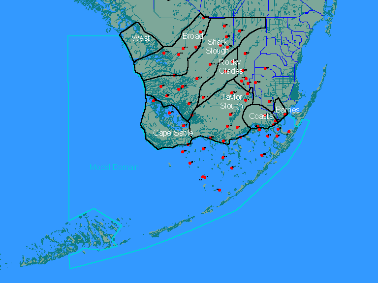
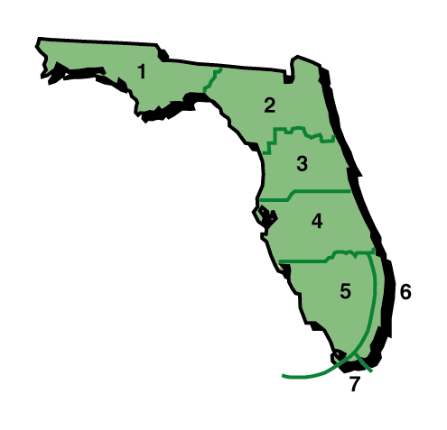
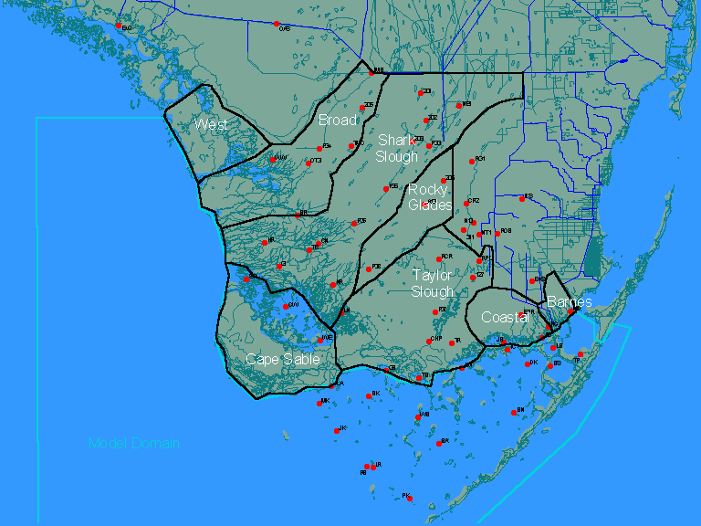
Locations of stations in the ENP rainfall monitoring network are shown below:
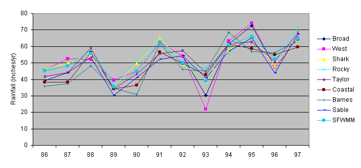
Station labels and periods of record are listed in an attached table. Estimates of spatially-averaged rainfall values for each ENP watershed and Florida Bay are required for estimating Florida Bay inputs. These have been computed on a daily basis using non-missing values from stations within each region. In some cases, values from adjacent watersheds have also been used to provide a more complete geographic coverage and to fill in missing values. Rainfall estimates for the West basin are based upon data from southern portions of the adjacent Broad and Shark River basins. No attempt has been made to screen the data for outliers or unrepresentative values. It is assumed that such screening has already been conducted by ENP staff in processing the measurements. The estimates are based upon simple arithmetic averages of stations with non-missing data. Application of spatial weighting schemes and screening for outliers might yield more accurate values. Yearly total rainfall values for each ENP basin are listed in an attached table. Strong year-to-year covariance across basins is evident in the yearly time series:
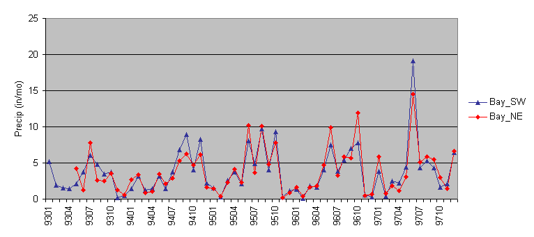
The following figure shows monthly total rainfall values computed for the northeastern and southwestern portions of Florida Bay using data from the ENP marine monitoring network:
Yearly total rainfall values for each portion of the bay are listed in the attached table. Stations in the northeastern portion of the Bay started operation in May 1993. A high correlation between rainfall values in these two regions of the Bay is evident:
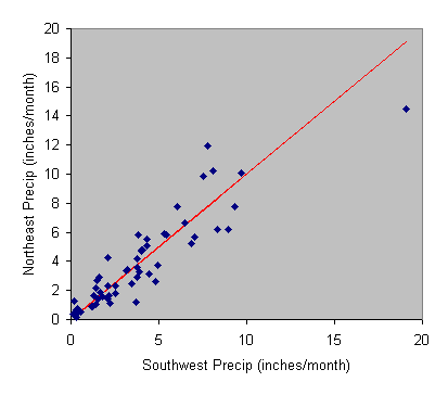
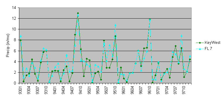
Stations from the southwest portion of the Bay (which have a longer period of record) provide an unbiased estimate of rainfall over the northeastern portion. Based upon these results, a single rainfall time series has been derived for the Bay using all stations from the ENP marine monitoring network. This network covers the northeastern and central portions of the model domain. Averages from these stations are assumed to represent the entire model domain. Because of the dominance of ocean currents, it is unlikely model results in the western and extreme southern portions of the model domain will be sensitive to atmospheric inputs. Additional data compilation effort would required if this turns out not to be the case. Monthly rainfall values obtained from the NCDC for Florida Region 7 (regional average) and a single station on Key West are plotted below:
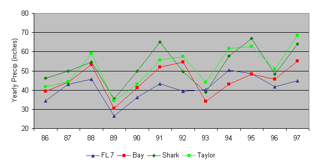
The FL 7 time series, which has a complete record dating back to 1895, is used to estimate runoff flows and loads from the Keys. Yearly total rainfall values for 1986-1996 are listed in an attached table. Comparison of ENP, Bay, & Keys Rainfall The following figure compares yearly total rainfall values for two ENP basins, the Bay, and the Keys (FL 7), as derived above:
Results generally reflect a north to south decreasing gradient in precipitation in most years, with the exceptions of 1993 and 1994, when rainfall over the Bay was apparently lower than rainfall over ENP or the Keys. The following additional tasks may provide refined rainfall estimates for use in this project:
Such efforts may be justified if the Bay water quality model is found to be sensitive to direct rainfall inputs and/or inflows from ENP watersheds. http://www.shore.net/~wwwalker/flabay/keys_ww.htm Updated: 03/30/02 |