Estimation of Inputs
to Florida Bay
Inputs from Florida Mainland - FlowsJuly 1998 |
||||||||||||||||||||||||||||||||||||||||||||||||||||||||||||||||||||||||||||||||||||||||||||||||||||||||||||||||||||||||||||||||||||||||||||||||||||||||||||||||||||||||||||||||||||||||||||||||||||||||||||||||||||||||||||||||||||||||||||||||||||||||||||||||||||||||||||||||||||||||||||||||
Maps:
Direct measurements made by the U.S. Geological Survey provide one resource for estimating Florida Bay inflows. Station locations are shown on the attached map. Periods of record are listed in a subsequent section. Given the diffuse nature of the inflows, it not likely that these sites reflect all freshwater inflows to Florida Bay from the mainland. Measured flows available for only a portion of the period of interest. For these reasons, the modeling approaches described below are as the primary basis for estimating inflows from the mainland. Comparisons of observed and predicted inflows are presented in a subsequent section. The South Florida Water Management Model predicts water balances for South Florida on a uniform grid (2 x 2 mile cells). The model produces output at a daily time step for Calendar Years 1965-1995. Output from the 95Base run of the Everglades Restudy most closely approximates current watershed and water-management conditions. The grid size and topographic data used in the model may not be not sufficient to characterize the spatial distribution of Bay inflows. The basic water-budget calculations performed by the model, however, should be reasonably accurate. The model provides useful estimates of spatially-distributed rainfall and evapotranspiration rates over most of ENP for the 1965-1995 period. Linkage of Bay inflow estimates to the SFWMM would be desirable for evaluating the effects of future changes in water management. Modeling efforts are underway at WES and USGS (Swain, 1998) to developed a detailed hydrologic model that will serve as a linkage between the SFWMM and Florida Bay water quality models. Given that these results are not yet available and given the immediate need for estimates of Bay inflows that can be used in preliminary calibrations of the Bay water quality models, a simple water-balance approach is used below to estimate Bay inflows from various ENP watersheds. The resulting estimates can be refined or replaced with output from the WES/USGS watershed models, once this output is available. One advantage of the water budget approach is that it can be applied to produce inflow estimates for recent years (1996-1997), which are important for calibrating and testing Bay water quality models. Applications of the SFWMM are currently restricted to the 1965-1995 period and are not likely to be extended soon. The following water balance model is used below to generate outflow time series for each ENP basin:
where,
An empirical function of the following form is used to represent the basin stage/discharge relationship:
where,
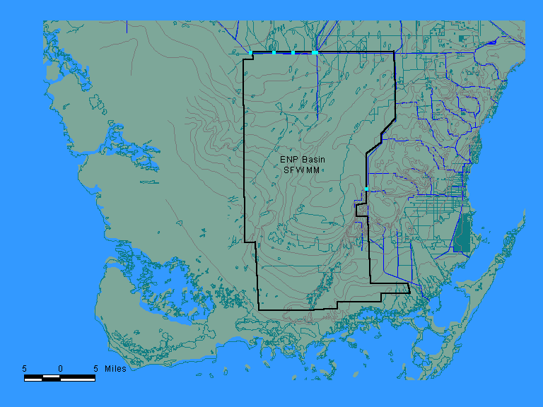
Refinements to the above model would consider variations in marsh surface area as a function of elevation. The equations can be combined and integrated numerically to produce an outflow time series, given inflow, rainfall, and evapotranspiration time series, the basin area, and estimates of the empirical coefficients a and b. Kadlec and Knight (1996) show that discharge is expected to vary with the cubic power of mean depth in a wetland with constant surface area. This provides an initial estimate of b = 3 for a wetland with constant area. Given that the wetland area (portion inundated) is not constant, however, calibrated values of b may differ from 3. The coefficients a and b are calibrated to simulate mean monthly water depths at a representative marsh monitoringe site in each basin. It should be noted that the coefficients a and b influence only the timing of the predicted outflows. The total outflow volume is constrained by the overall water blance (inflows + rainfall - evapotranspiration). The feasibility of predicting basin outflows using this approach is demonstrated by applying the model to the monthly water budget data produced by the South Florida Management Model for the 824-mi2 ENP Basin. Approximate ENP basin boundaries defined in SFWMM are shown below:
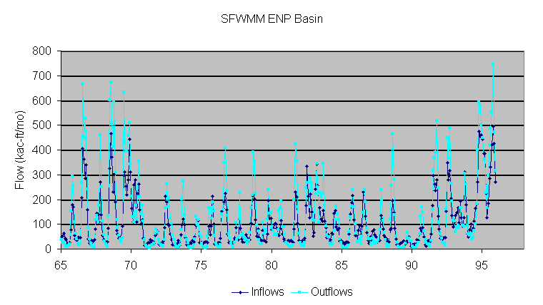
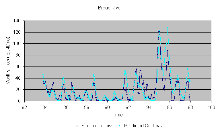
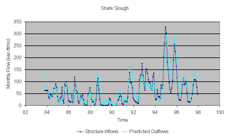
Structure inflows (blue squares) include the S12's, S333, and S174 (combined discharge through S332 & S175). Monthly total inflows and total outflows for the 1965-1995 simulation period are plotted in the following figure:
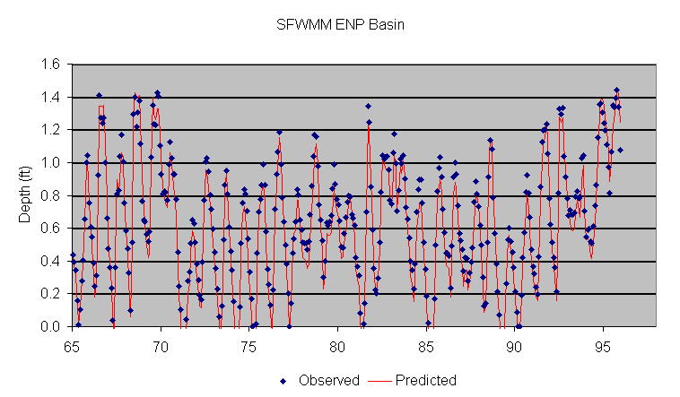
Total inflows primarily reflect structure inflows. Total outflows primarily reflect overland flows. Both terms are influenced to a minor extent by groundwater flows and levee seepage. A strong correlation between inflows and outflows is evident. Differences between inflows and outflows primarily reflect rainfall, evapotranspiration, and change in storage. Average water depths have been calculated from the change-in-storage term provided in SFWMM output; depths assume a constant basin area of 824 mi2 (206 model grid cells). Coefficients of the depth/discharge relationship (a,b) have been calibrated to match the simulated mean depth time series:
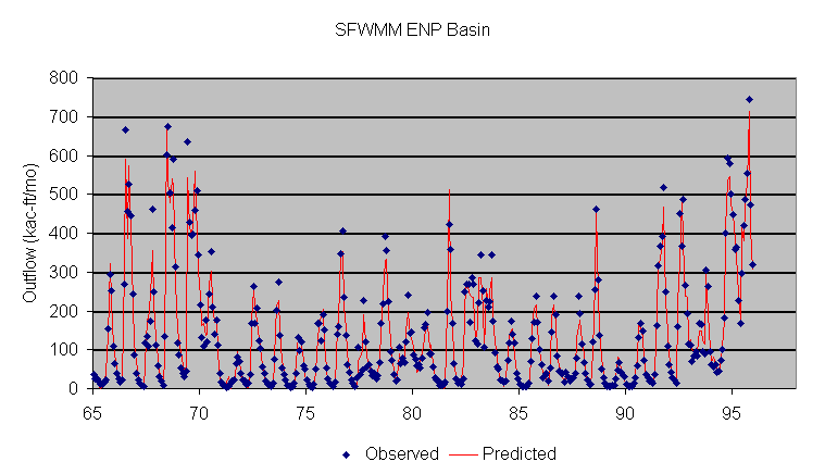
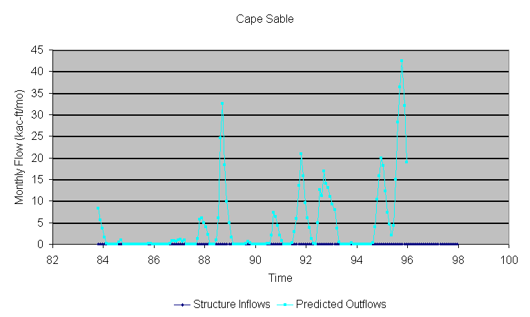
The following figure compares "observed" and predicted monthly total outflows from the SFWMM ENP basin:
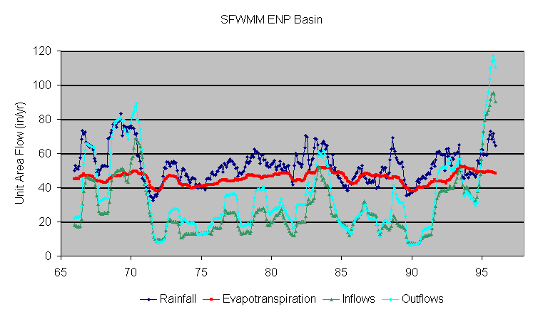
The "observed" values are those generated by the SFWMM from water-balance calculations on the 2 x 2 mile grid. The "predicted" flows are derived from the calibrated basin-wide water balance model driven by inflow, rainfall, and evapotranspiration time series. These estimates cannot be translated directly to Bay inflows, since a portion of the outflows from this basin are towards the west and the basin does not include all of the ENP watershed. A more detailed cell-by-cell polling of SFWMM output would be required to extract Bay inflows. Results demonstrate that the basin-wide water-balance model produces outflow estimates which are similar to those produced by the SFWMM. The long-term record represented by the SFWMM provides important perspectives on temporal variations in flow driven by climatologic factors. The following figure shows 12-month rolling totals of Rainfall, ET, Inflows, and Outflows for the SFWMM ENP Basin over the 1965-1995 period, expressed as unit area flows. The apparent correlation between rainfall and ET reflects the dependence of ET on soil moisture levels as water levels drop. Over this period, annual outflow ranged from 10 to 120 inches/yr.
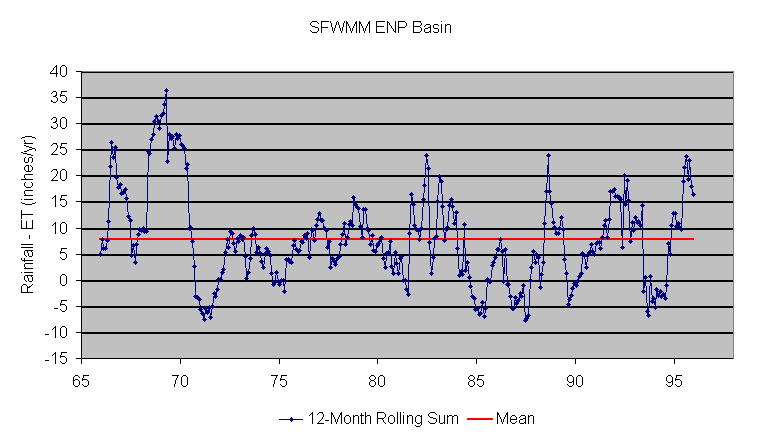
The following figure plots net runoff from ENP watersheds (Rainfall -ET). Over the 1965-1995 period, net runoff averaged 7.7 inches/yr and ranged from -7.8 to +36 inches/yr. Compilation of measured rainfall and ET values will be necessary in order to extend the period of record beyond 1995. Consideration of spatial variations in these values will be required to develop more accurate estimates of net runoff from each watershed.
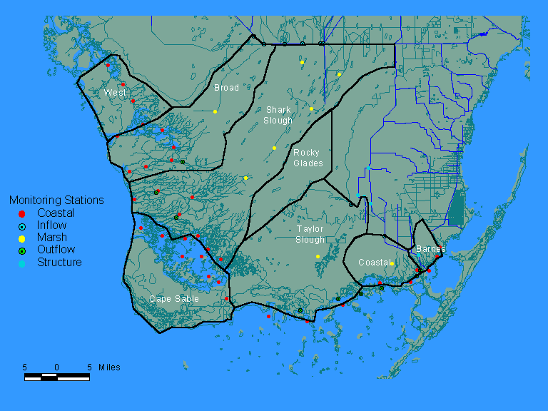
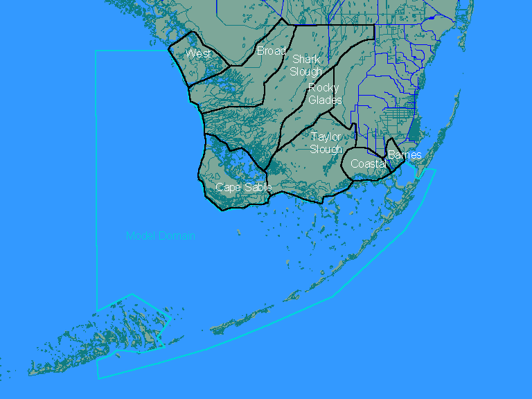
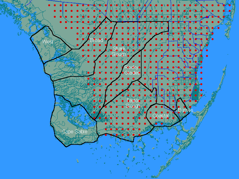
These results demonstrate that inflows to Florida Bay are strongly dependent on water deliveries to ENP from the WCA's. Although local contributions from the ENP watershed (Rainfall - ET) are negative in ~50% of the 12-month periods (range, -7. to +36 inches/yr), basin total outflows are positive in every 12-month period (range 10 to 120 inches/yr). Applications to ENP Watersheds Using the above methodology, water-balance calculations have been performed for the ENP watersheds defined in the following figure:
Basin boundaries have been estimated from GIS layers representing land contours and hydrography. Boundaries are approximate at best. Monitoring station categories shown on the map include:
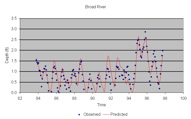
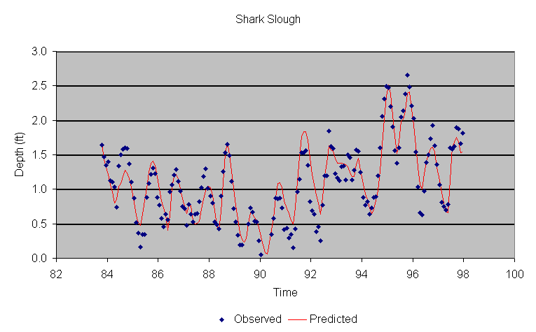
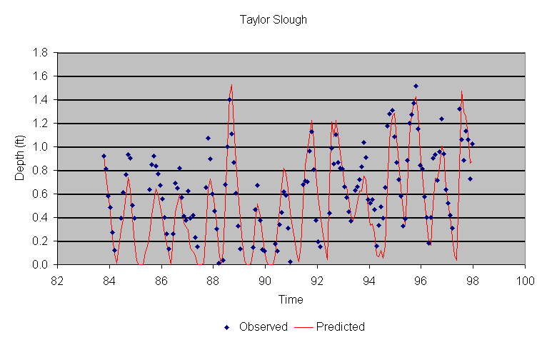
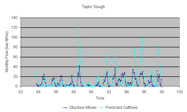
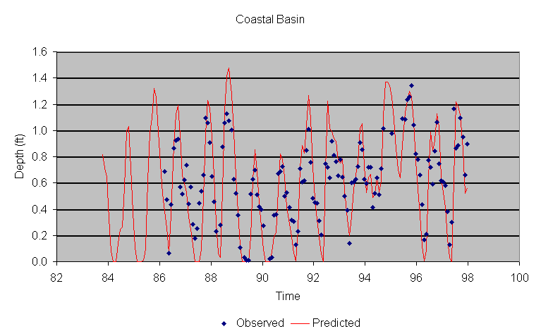
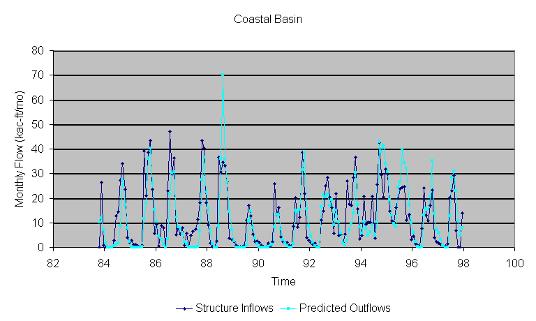
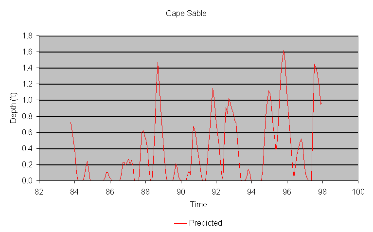
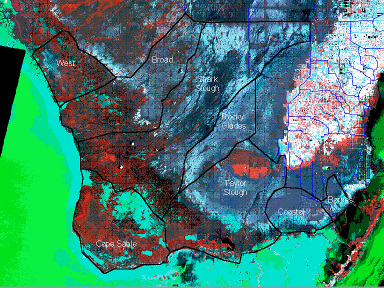
Click here to view the watershed map overlayed on landsat image. Click here to view the watershed map and Florida Bay water quality model domain. Development of a monthly rainfall time series (October 1985 - December 1997) for each watershed based upon data from the ENP hydrologic monitoring network is described in a separate section of this report. To provide a slightly longer period for testing the water budget models, the period of record has been extended back to October 1983 using average rainfall values derived from SFWMM input data files for grid cells in each basin. Click here to see SFWMM grid overlayed on ENP watershed map. For October 1985-December 1995, evapotranspiration (ET) rates have been extracted from SFWMM output (95Base run) and averaged over grid cells in each basin. Average monthly ET rates computed from 1986-1995 output have been used for 1996-1997. Considering the importance of 1996-1997 results to the water quality modeling effort, refinements to the ET estimates for this period might be derived from recent measurements by the USGS, once results become available. The SFWMM grid does not cover the entire area of interest. Rainfall and ET values for excluded areas have been estimated from neighboring grid cells. The equations do not directly account for inter-basin flows or levee seepage which is known to occur along the eastern boundary of the Park (into L31N, L31W, and C111 canals, VanLent et al, 1993; ENP, 1994; Walker, 1997). Although S332 and S175 are generally considered inflow points to Taylor Slough, substantial portions of these inflows seep back into the L31N and/or C111 canals because of strong west-to-east hydraulic gradients and permeable soils. Appreciable portions of flows passing through S18C, S332, and S175 consist of recycled seepage from ENP. As indicated on the watershed map, northern portions of Taylor Slough and the Rocky Glades are excluded from the water budget calculations. These areas are assumed to drain primarily to the East into L31N and 31W canals (VanLent et al, 1993; ENP, 1994). The net inflows into southern Taylor Slough from northern Taylor Slough, the Rocky Glades, and discharges from S332 are assumed to be reflected in the measured flows at the Taylor Slough Bridge. Jones & Boyer (1997) used the Taylor Slough bridge flows exclusively to represent inflows to southern Taylor Slough. Including the S175 flows seems more consistent with the topography and provides a slightly better fit of the P37 stage hydrograph (see below), although this assumption needs further examination. Results of more detailed hydrologic modeling may provide better resolution of the flows in this area. The southern portion of the Rocky Glades basin does not have inflows from water management structures or direct outflows to Florida Bay. Land slope indicates that this basin discharges primarily to Shark Slough. Accordingly, this basin is considered part of Shark Slough for the purposes of generating Bay inflow estimates. Seepage losses from Northeast Shark Slough into L31N are not reflected in current calculations; these were reduced after 1991 with operation of structure G211, which raised canal stage in the northern portion of L31N by approximately 1 foot. The estimates do not account for potential interactions among the basins. Under certain conditions, for example, Shark Slough has overflowed into Taylor Slough through the Rocky Glades area (Van Lent et al., 1993). These interactions may be important impacts on the spatial distributions of outflows to Florida Bay and may therefore need to be considered in Phase II of this project. The "Barnes" basin drains into Barnes Sound which is part of the water quality model domain, but not part of Florida Bay. Outflows from S197 are assumed to occur without marsh interaction. This represents the only direct structure outflow into the model domain. Discharges through this structure are infrequent. Measurements of inflow through S343A and S343B (Broad River Basin) are available starting in January 1995. Prior to this date, inflows have been estimated using a correlation with Shark Slough inflows (S12ABCD+S333). The following table gives monitoring stations, preliminary calibration results and links to monthly time series plots for each basin:
The following table summarizes average water-balance terms for each basin, expressed as total volumes: Average Annual Flows (kac-ft/yr)
The following table summarizes average water-balance terms for each basin, expressed as unit area flows: Unit Area Flows (inches/yr)
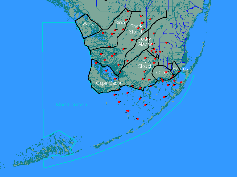
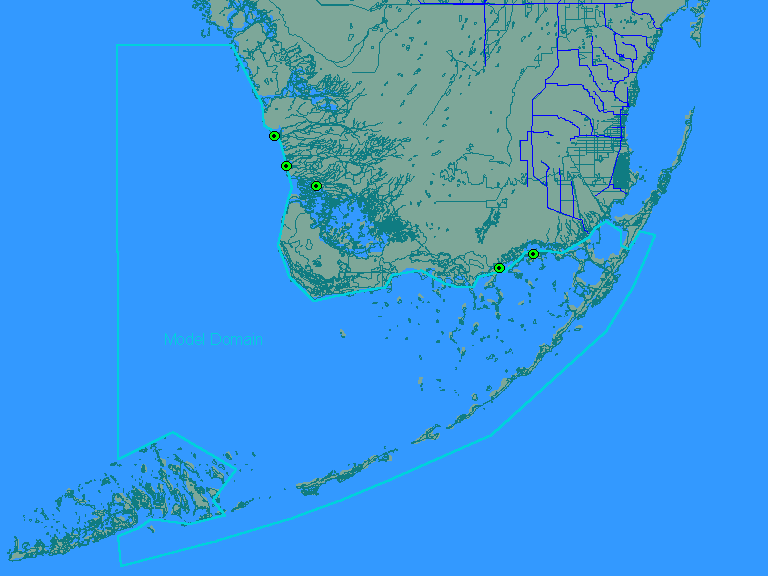
Rainfall and evapotranspiration rates dominate the water balances of each basin. Because rainfall and evapotranspiration rates are similar, basin outflows are similar to structure inflows. Net runoff (Rainfall - ET) from areas within the park averaged ~3 inches/year during this period. Uncertainty in the computed outflows is probably large, especially on short time steps. If the measured Inflow, Rainfall, and Evapotranspiration (ET) terms for the total basin are each assumed to have a relative standard error of 0.05 (standard error / mean), the computed relative standard error of the outflow term would be 0.18 (calculated by adding variances of individual terms). Uncertainty is amplified because the outflow computation is dependent upon the difference of two relatively large terms (rainfall - ET). Spatial Distribution of Bay Inflows Comparisons with flows measured by the USGS may provide a basis for refining the above flow estimates and for spatially allocating the outflows from each basin to inflow points represented in the Florida Bay Water Quality Model. The following inflow points are currently included in the model, as shown on the attached map:
Addition of new inflow points may be needed to reflect the entire inflow distribution. Allocation of the predicted basin outflows to specific model input puts is left to the water quality modeling team. The following additional tasks may provide improved estimates of Bay inflows from the Florida Mainland:
|
||||||||||||||||||||||||||||||||||||||||||||||||||||||||||||||||||||||||||||||||||||||||||||||||||||||||||||||||||||||||||||||||||||||||||||||||||||||||||||||||||||||||||||||||||||||||||||||||||||||||||||||||||||||||||||||||||||||||||||||||||||||||||||||||||||||||||||||||||||||||||||||||