Estimation of Inputs to Florida Bay
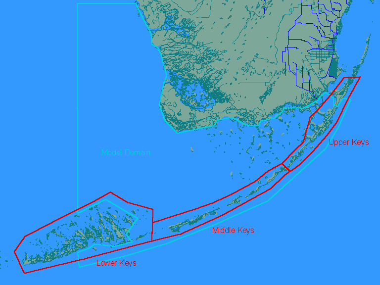
Inputs from Florida Keys - RunoffJuly 1998 Project Index | Provide Comments Introduction | Methods | Results | Potential Refinements This section develops estimates of flows and nutrient loads in stormwater runoff and wastewater from the Florida Keys. The methodology and assumptions are derived primarily from the draft Water Quality Protection Program for the Florida Keys National Marine Sanctuary (USEPA, 1993). Based upon the availability of land use data summaries, estimates are derived for three source areas (Upper, Middle, and Lower Keys), as shown below:
Most of the Lower Keys region is outside of the model domain. Calculations are driven by estimated 2010 land uses in each region (USEPA, 1993):
The following equations are used to estimate total runoff volumes and loads from each region:
where,
Runoff volumes are calculated using a constant surface runoff coefficient (runoff/rainfall) for each land use category. Runoff volumes are multiplied by assumed runoff concentrations for each land use category to estimate runoff loads. Factors to account for attenuation of runoff loads between points of generation and points of inflow to the Bay or Reef are included in the estimation procedure. Attenuation reflects losses in transport (lack of direct connection between impervious source areas and points of discharge to Bay or Reef) and runoff BMP's (swales, detention/retention areas). Transport losses of phosphorus, nitrogen, and suspended solids are estimated using average removal efficiencies reported by USEPA (1993b) for infiltration BMP's and assuming that such BMP's (or equivalent transport losses) are applied to 50% of the source areas in each region. While estimation of transport losses is difficult, ignoring them altogether would over-estimate loads reaching the bay or reef. Partitioning of nutrient species and estimates of other water quality components are derived using a framework which is similar to that used in estimating loads from the Florida mainland. Finally, coefficients to reflect the destination of runoff loads (Bay vs. Reef) are included; current estimates assume a 50/50 split between bay and reef discharges in each region. Calculations are performed on a monthly basis between October 1985 and December 1997 using a rainfall time series for the Keys region obtained from the National Climatic Data Center (Florida Region 7). This data set is described in a separate section of this report. Input values and results are listed in the attached tables:
The output file contains a monthly average flow (m3/sec) and flow-weighted-mean concentration (ppm) for each water-quality component, for each month between October 1985 and December 1997, and for 6 inflow points (discharges to bay & reef from 3 areas). An excel workbook will be provided to generate output files for alternative sets of assumptions. The following tasks would provide refined estimates of runoff volumes and loads from the Keys:
Such efforts may be justified if the Bay water quality model is found to be sensitivite to runoff loads. http://www.wwwalker.net/flabay/keys_run.htm Updated: 03/30/02 |