P8 Runoff Parameters Consistent with SLAMM Simulations
Impervious Areas
P8 and the Source Area Loading & Management Model (SLAMM,
PV & Assoc., 2007, http://www.winslamm.com)
are used widely in Wisconsin for designing urban stormwater BMP's. SLAMM's runoff algorithm and input requirements are more complex than P8's.
SLAMM permits detailed specification of individual source area types (roofs,
streets, etc). This allows for evaluation of BMP's targeting
individual source areas. SLAMM has been
calibrated to extensive runoff data from Wisconsin watersheds and tested
elsewhere (R. Pitt,
Small Storm Hydrology, SLAMM Version 9.2.5 documentation). P8's
runoff algorithm is simpler and requires specification of two fundamental
parameters driving simulation of runoff from impervious areas (depression
storage & runoff coefficient), based upon professional judgment with general
guidance from the literature.
P8 watershed parameters yielding predictions of impervious-area runoff from Wisconsin watersheds similar to SLAMM's
are described below. Since each model has its unique features and purposes, it
is not implied that the parameters allow P8 to be used in place of SLAMM.
Rather, the values provide indirect calibrations to Wisconsin runoff data
upon which SLAMM is based. It also provides reasonable consistency of
P8 and SLAMM results for users applying both models simultaneously to specific
design projects. SLAMM Version 9.2.5 has been used to develop the
calibrations. The analysis is based on simulations of May 15 - October 31, 1981 rainfall
in Madison. A
previous study by the USGS (Corsi, 1996) determined this to be
representative of an average year.
The applicability of the calibrations outside of Wisconsin
has not been evaluated.
The calibrations apply specifically to runoff from directly-connected impervious
areas, which typically drives BMP designs.
Walker (2007)
shows P8 calibrations (DS & R1) to 7 impervious-area categories considered in SLAMM. The
calibrated runoff
coefficients (R1) apply while the cumulative rainfall/snowmelt during a given event is
less than 0.8 inches ("breakpoint" specified on the
Edit General screen). The runoff coefficient is constrained to 1.0
above 0.8 inches (see runoff model description). Calibrations are based upon runoff coefficient vs. cumulative rainfall
tables for Wisconsin watersheds specified in the SLAMM input file "WI_SL06
DEC06.rsv".
The table below lists results for SLAMM impervious area types
and standard land use categories. Each category has a
specific distribution of impervious area types, as listed in the table.
There are essentially three ways to simulate a SLAMM standard land use category in P8:
- Specify a separate P8 watershed for each impervious area
type. Use the calibrated depression storage and runoff coefficient
values listed below for each impervious area type. Add another
subwatershed to reflect the pervious and indirectly connected area. Link
each watershed to a single P8 Pipe
device, the outflow from which would reflect the combined runoff from
the entire watershed.
- A simpler method uses a single P8 watershed with
depression storage and runoff coefficient based upon the weighted average
across individual impervious area types, as listed in the table below.
This method is approximate because a single value for depression storage
would not reflect the distribution of values across impervious area types.
The directly-connected impervious fraction for each category can be derived
from the table below or adjusted to site-specific
conditions. Runoff predictions
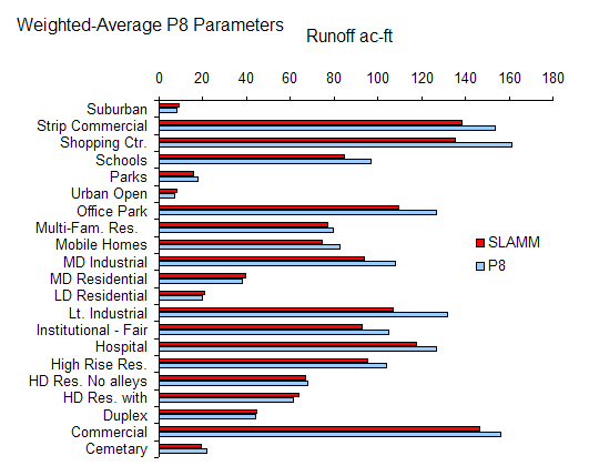
using this method are compared in the figure below.
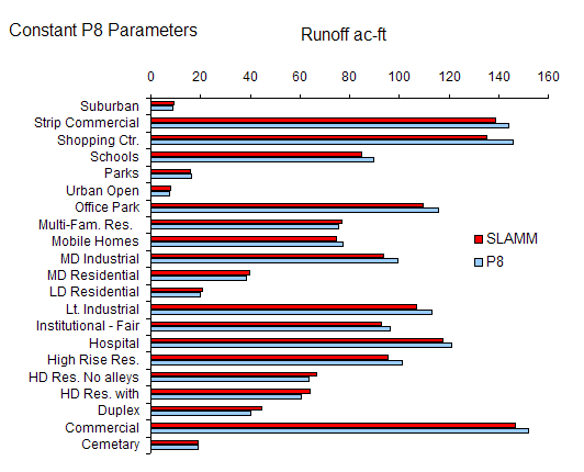
- An even simpler method uses a single P8
watershed with parameters for impervious runoff (DS =0.022, R1=0.8).
Agreement between the models is similar to or better than that based upon weighted-average coefficients
(Method 2 above). As far as P8 is concerned, runoff from impervious
areas in typical urban watersheds is primarily driven by the overall
impervious fraction and the distribution of
impervious area types is of secondary importance. That distribution is
more important in SLAMM, which allows evaluation of BMP's
targeting specific source areas.
Runoff predictions using this method
are compared in the figure below.
Calibration Results:
|
|
P8 Coefficients |
Watershed Area Fractions |
|
|
|
|
|
|
|
SLAMM Impervious Area Type |
|
SLAMM Source Area Category |
Depres. Storage inches |
Imperv Runoff Coef |
Pervious |
Indirect Connected |
Total Directly Connected |
Flat Roofs |
Pitched Roofs |
Connected Impervious |
Connected Unpaved |
Smooth Textured Streets |
Intermediate Txt Streets |
Rough Txt Streets |
|
|
|
|
|
|
|
|
|
|
|
|
|
|
|
SLAMM Impervious Area Type |
|
|
|
|
|
|
|
|
|
|
|
|
|
|
|
Flat Roofs |
0.080 |
0.907 |
|
|
1.000 |
1.000 |
|
|
|
|
|
|
|
Pitched Roofs |
0.030 |
1.000 |
|
|
1.000 |
|
1.000 |
|
|
|
|
|
|
Connected Impervious |
0.002 |
0.973 |
|
|
1.000 |
|
|
1.000 |
|
|
|
|
|
Connected Unpaved |
0.200 |
0.962 |
|
|
1.000 |
|
|
|
1.000 |
|
|
|
|
Smooth Textured Streets |
0.022 |
0.701 |
|
|
1.000 |
|
|
|
|
1.000 |
|
|
|
Intermediate Txt Streets |
0.025 |
0.644 |
|
|
1.000 |
|
|
|
|
|
1.000 |
|
|
Rough Txt Streets |
0.030 |
0.654 |
|
|
1.000 |
|
|
|
|
|
|
1.000 |
|
|
|
|
|
|
|
|
|
|
|
|
|
|
|
SLAMM Standard Land Use Category - Weighted-Average P8 Coefficients |
|
|
|
|
|
|
|
|
|
|
|
|
|
|
|
Cemetery |
0.008 |
0.934 |
0.874 |
0.007 |
0.120 |
0.006 |
|
0.100 |
|
0.007 |
0.007 |
|
|
Commercial Downtown |
0.040 |
0.880 |
0.046 |
0.001 |
0.953 |
0.407 |
|
0.324 |
|
0.200 |
0.022 |
|
|
Duplex |
0.020 |
0.821 |
0.609 |
0.121 |
0.271 |
0.000 |
0.045 |
0.093 |
|
0.000 |
0.000 |
0.133 |
|
HD Res. with Alleys |
0.024 |
0.817 |
0.481 |
0.138 |
0.381 |
0.000 |
0.136 |
0.043 |
|
0.054 |
0.132 |
0.016 |
|
HD Res. No alleys |
0.017 |
0.875 |
0.469 |
0.131 |
0.399 |
0.000 |
0.103 |
0.161 |
|
0.045 |
0.090 |
|
|
|
|
|
|
|
|
|
|
|
|
|
|
|
|
High Rise Res. |
0.032 |
0.868 |
0.356 |
0.012 |
0.632 |
0.190 |
|
0.261 |
|
0.091 |
0.045 |
0.045 |
|
Hospital |
0.039 |
0.903 |
0.231 |
0.006 |
0.763 |
0.318 |
0.039 |
0.297 |
|
0.042 |
0.066 |
|
|
Institutional - Fair C & G |
0.017 |
0.909 |
0.364 |
0.036 |
0.600 |
0.054 |
0.084 |
0.341 |
|
0.040 |
0.068 |
0.013 |
|
LT Industrial |
0.029 |
0.906 |
0.205 |
0.088 |
0.707 |
0.205 |
0.026 |
0.368 |
|
0.018 |
0.087 |
0.003 |
|
LD Residential |
0.026 |
0.790 |
0.796 |
0.079 |
0.126 |
0.019 |
|
0.037 |
|
0.022 |
0.042 |
0.006 |
|
|
|
|
|
|
|
|
|
|
|
|
|
|
|
MD Residential no alleys |
0.029 |
0.796 |
0.622 |
0.135 |
0.242 |
0.045 |
|
0.069 |
|
0.037 |
0.076 |
0.015 |
|
MD Residential with alleys |
0.026 |
0.783 |
0.589 |
0.169 |
0.242 |
0.032 |
|
0.053 |
|
0.135 |
0.022 |
|
|
MD Industrial |
0.026 |
0.922 |
0.167 |
0.208 |
0.625 |
0.168 |
0.019 |
0.363 |
|
0.062 |
0.011 |
0.002 |
|
Mobile Homes |
0.032 |
0.913 |
0.502 |
0.011 |
0.487 |
0.169 |
|
0.262 |
|
0.006 |
0.030 |
0.020 |
|
Multi-Fam. Res. No alleys |
0.025 |
0.882 |
0.462 |
0.063 |
0.474 |
0.034 |
0.141 |
0.148 |
0.005 |
0.061 |
0.085 |
|
|
|
|
|
|
|
|
|
|
|
|
|
|
|
|
Office Park |
0.019 |
0.914 |
0.263 |
0.006 |
0.731 |
0.132 |
|
0.489 |
|
0.031 |
0.080 |
|
|
Urban Open Space |
0.027 |
0.733 |
0.951 |
0.000 |
0.049 |
0.006 |
|
0.006 |
|
0.017 |
0.020 |
|
|
Parks |
0.010 |
0.873 |
0.856 |
0.041 |
0.103 |
0.001 |
0.001 |
0.068 |
|
0.010 |
0.023 |
|
|
Schools |
0.026 |
0.908 |
0.421 |
0.014 |
0.565 |
0.150 |
|
0.329 |
|
0.027 |
0.043 |
0.016 |
|
Shopping Ctr. |
0.023 |
0.936 |
0.083 |
0.000 |
0.917 |
0.216 |
|
0.630 |
0.003 |
0.042 |
0.022 |
0.004 |
|
|
|
|
|
|
|
|
|
|
|
|
|
|
|
Strip Commercial |
0.025 |
0.892 |
0.079 |
0.014 |
0.907 |
0.197 |
0.037 |
0.472 |
|
0.086 |
0.115 |
|
|
Rural Residential / Suburban |
0.040 |
0.726 |
0.904 |
0.040 |
0.056 |
0.016 |
0.000 |
0.000 |
|
0.007 |
0.033 |
|
Predicted runoff
from directly connected impervious surfaces for each standard land use and
model, using impervious fractions and weighted-average P8 parameters (depression
storage and runoff coefficient) listed in the
above table :
Predicted runoff
from directly connected impervious surfaces for each standard
land use and model, using impervious fractions listed in the
above table and constant P8 parameters (DS =
0.022 inches, R1=0.8):
Pervious Areas
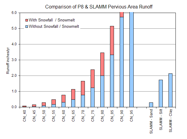
The figure below compares pervious area runoff volumes
predicted by P8 and SLAMM. P8 results are shown as a function of Curve
Number with and without seasonal factors (snowfall/snowmelt, frozen soil, not
considered in SLAMM). SLAMM results are shown for three soil
textures and the "Undeveloped" source area category.
These results are provided for general information. P8
and SLAMM use fundamentally different algorithms for pervious area runoff, so differences
in the results could be due to several factors.
|
5 Years of Madison
Precipitation (1980-1984); Total Precip = 32.7 in/yr, Snowfall = 2.8
in/yr, Rainfall = 29.9 in/yr |
| |
|
|
|
|
|
|
|
Approximate
Equivalent Curve Numbers |
|
Snowfall/Snowmelt |
With |
Without |
|
|
|
|
|
SLAMM - Sand |
50 |
60 |
|
|
|
|
|
SLAMM - Silt |
71 |
78 |
|
|
|
|
|
SLAMM - Clay |
73 |
81 |
|
|
|
|