| D R A F T |
|
|
|
|
|
|
|
|
|
|
|
|
|
|
07-07-2011 |
| A P P E N D I X |
| Trends in
Onondaga Lake Nearshore Monitoring Data |
| Onondaga Lake Ambient Monitoring
Program - 2011 Report |
| prepared for |
| Ecologic, LLC |
| & |
| Onondaga County
Department of Water Environment Protection |
| by |
| William W.
Walker, Jr., Ph.D. |
| & |
| Jeffrey D.
Walker, M.Eng. |
|
|
|
|
|
|
|
|
|
|
|
|
|
|
|
|
|
|
|
| Download Latest
DRAFT Main Report --> |
MS Word Version |
Acrobat
PDF Version |
|
|
|
|
|
|
|
|
|
|
|
|
|
|
|
|
|
|
|
|
|
|
|
|
|
|
| Summary of Trend
Analysis Results |
|
Trend Slopes in Percent Per Year |
|
May-September
1999-2010 |
|
|
|
|
|
|
|
|
|
|
|
|
|
|
|
|
|
|
|
|
|
|
| |
|
|
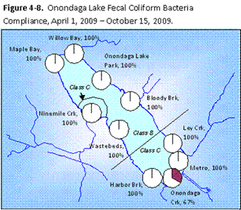
Freq. of Secchi Depth < 1.2 m |
Turbidity |
Fecal Coliform Bacteria |
E. Coli
Bacteria |
| Site |
Description |
Dry |
Wet |
All |
Adj |
Dry |
Wet |
All |
Adj |
Dry |
Wet |
All |
Adj |
Dry |
Wet |
All |
Adj |
| 9MILE |
Ninemile Creek |
-2 |
-2 |
-2 |
-2 |
-13 |
-12 |
-13 |
-12 |
1 |
-2 |
1 |
1 |
-5 |
-4 |
-6 |
-5 |
| MAPLE |
Maple Bay |
-2 |
-2 |
-2 |
-2 |
-13 |
-13 |
-14 |
-13 |
3 |
-1 |
1 |
1 |
-1 |
-4 |
-2 |
-2 |
| WIL |
Wilkenson |
-1 |
-2 |
-1 |
-1 |
-14 |
-12 |
-13 |
-13 |
1 |
-1 |
0 |
1 |
-4 |
-5 |
-4 |
-4 |
| LKPK |
Lake Park |
-1 |
-3 |
-2 |
-2 |
-14 |
-13 |
-14 |
-14 |
1 |
-1 |
0 |
0 |
-6 |
-6 |
-7 |
-7 |
| BLBRK |
Bloody Brook |
-7 |
-3 |
-3 |
-2 |
-17 |
-18 |
-18 |
-17 |
2 |
-16 |
-13 |
-6 |
-5 |
-14 |
-11 |
-5 |
| LS_N |
All Northern Sites |
-1 |
-3 |
-2 |
-2 |
-14 |
-14 |
-14 |
-14 |
2 |
-1 |
0 |
1 |
-4 |
-4 |
-5 |
-4 |
| LEY |
Ley Creek |
-4 |
-7 |
-7 |
-6 |
-16 |
-19 |
-17 |
-16 |
-1 |
-12 |
-7 |
-5 |
-2 |
-13 |
-9 |
-7 |
| MID_S |
Mid South |
-3 |
-5 |
-3 |
-3 |
-13 |
-19 |
-16 |
-15 |
15 |
-1 |
9 |
10 |
3 |
-6 |
0 |
1 |
| HARB |
Harbor Brook |
-3 |
-6 |
-5 |
-5 |
-13 |
-17 |
-15 |
-14 |
8 |
-2 |
-1 |
2 |
1 |
-2 |
-2 |
0 |
| LS_S |
All Southern Sites |
-3 |
-6 |
-5 |
-5 |
-14 |
-18 |
-16 |
-15 |
7 |
-5 |
0 |
2 |
0 |
-9 |
-4 |
-2 |
| LS_ALL |
All Lakeshore |
-2 |
-3 |
-3 |
-2 |
-14 |
-15 |
-15 |
-14 |
5 |
2 |
3 |
4 |
-2 |
-5 |
-4 |
-3 |
| SOUTH |
South Deep |
-2 |
-2 |
-2 |
-2 |
-5 |
-7 |
-5 |
-5 |
1 |
-1 |
0 |
0 |
-2 |
0 |
-1 |
-1 |
|
|
|
|
|
|
|
|
|
|
|
|
|
|
|
|
|
|
|
| Significance
levels |
Decreasing |
p < .05 |
p < .10 |
Increasing |
p<.05 |
p<.10 |
|
Trend Analysis Method: |
LinearRegression |
| Trend Slopes
expressed as % of values < 1.2 m per year for Secchi and % of long-term
geometric mean for turbidity and bacteria |
|
|
|
|
| Dry/Wet samples
classified based upon 3-day antecedent precipitation at Hancock Airport
<> 0.2 inches |
|
|
|
|
|
|
|
| Adj. = All data
adjusted for correlations with antecedent rainfall by linear regression
before performing trend analysis. |
|
|
|
|
|
|
|
|
|
|
|
|
|
|
|
|
|
|
|
|
|
|
|
|
| Detailed Results |
|
|
Description |
|
|
|
|
|
|
|
|
|
|
|
|
| Library |
|
|
|
|
All Files |
|
|
|
|
|
|
|
|
|
|
|
|
|
| Trend
Summary for Each Method |
|
Repeats Above Table for Each Statistical Method
(Linear Regression, Mann-Kendall, Seas.-Kendall) |
|
|
| Means
& Trends by Region |
|
|
Long-Term Means and Trends by Lake Region for Each
Variable |
|
|
|
|
|
|
| Yearly
Time Series |
|
|
Wet vs. Dry Weather; All Values; All vs. Adjusted Values |
|
|
|
|
|
|
| Monthly
Time Series |
|
|
Wet vs. Dry Weather; All Values; All vs. Adjusted Values |
|
|
|
|
|
|
| Weekly
Time Series |
|
|
Wet vs. Dry Weather; All Values; All vs. Adjusted Values |
|
|
|
|
|
|
| Box
Plots - Site vs. Weather |
|
|
Frequency Distributions by Site & Weather
(Long-Term Sites) |
|
|
|
|
|
|
| Box
Plots - Site vs. Weather - All |
|
Frequency Distributions by Site & Weather
(including WBEDS and OC_OUT) |
|
|
|
|
|
| Means
by Site & Weather |
|
|
Long-term Nearshore and South Deep Sites
(2002-2010); Sorted Clockwise |
|
|
|
|
| Means
by Site & Weather - All Sites |
|
All Nearshore Sites (Including Allied Waste Beds
& Onondaga Creek Outlet) |
|
|
|
|
|
| Regressions
vs Antecedent Rainfall |
|
Regression Slopes; Scatter Charts; Rainfall vs.
Year; |
|
|
|
|
|
|
|
| Trend
Slopes 1999-2010 |
|
|
Trend Slopes vs. Weather, Site, and Statistical
Method, 1999-2010 data |
|
|
|
|
|
| Trend
Slopes 2002-2010 |
|
|
Trend Slopes vs. Weather, Site, and Statistical
Method, 2002-2010 data |
|
|
|
|
|
| Statistical
Summary 1999-2010 |
|
Statistical Summary of Trend Analysis Results by
Site, Variable, and Weather, 1999-2010 data |
|
|
| Hydrologic
Conditions |
|
|
Rainfall Frequency Distributions, Time Series,
and Correlations with Lake Inflow |
|
|
|
|
| AMP
Database Time Series |
|
|
Time Series Analysis Output by Site &
Variable, AMP Water Quality Database,
All Samples |
|
|
|
| AMP
Statistical Framework |
|
|
Analysis of Variance, Trends by Season, AMP
Statistical Framework, All Samples |
|
|
|
|
| Trends at Lake
& Tributary Sites |
|
AMP Water Quality Database, All Lake and Tributary
Sites |
Download
AMP Database Output Viewer |
|
|
|
|
|
|
|
|
|
|
|
|
|
|
|
|
|
|
|
|
|
| AMP Database:
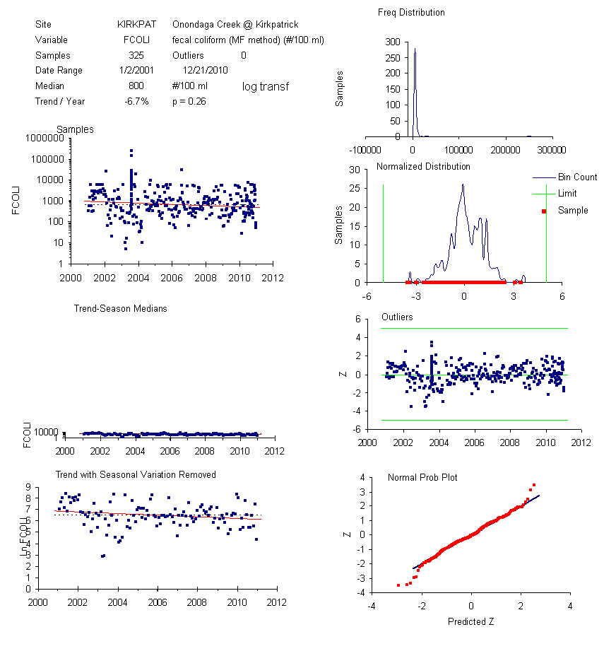
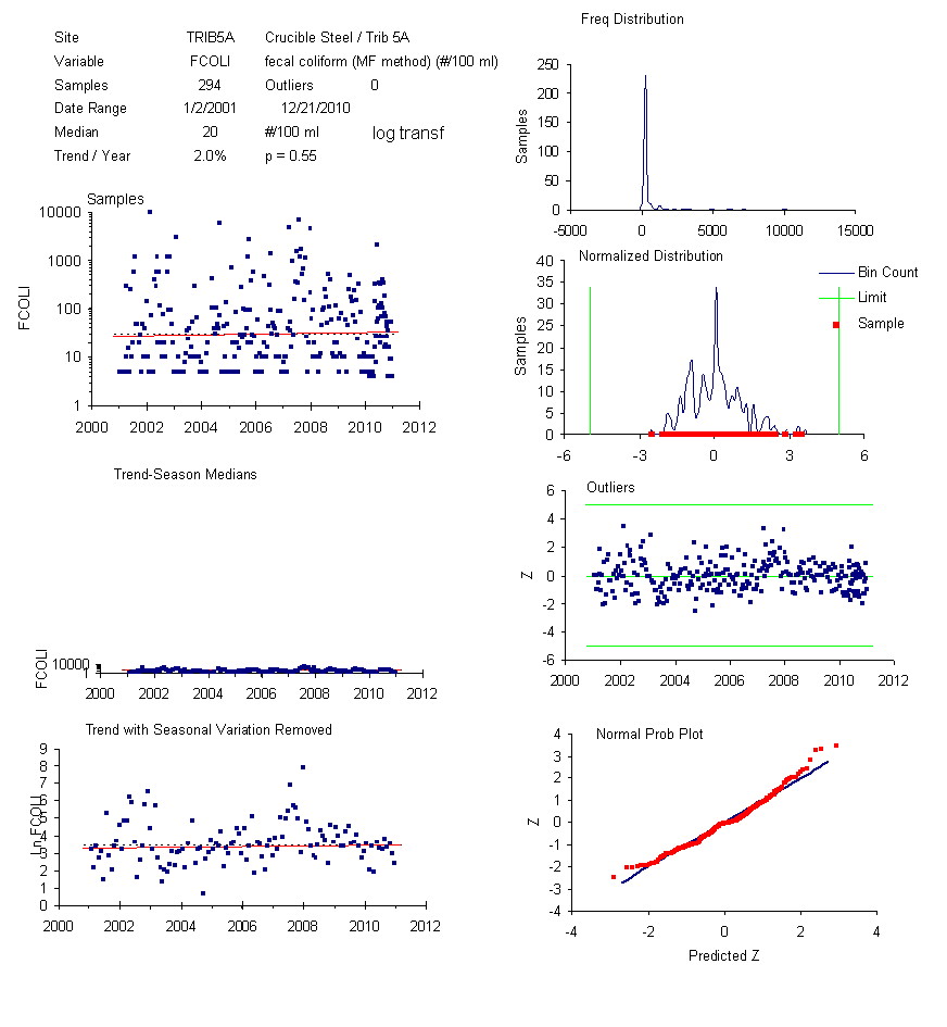
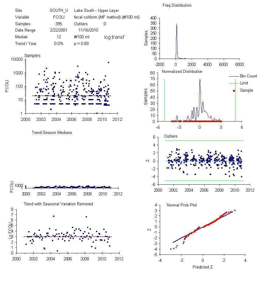
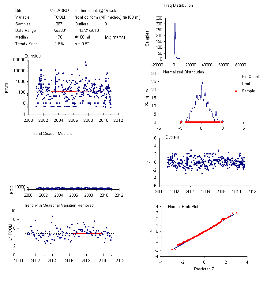
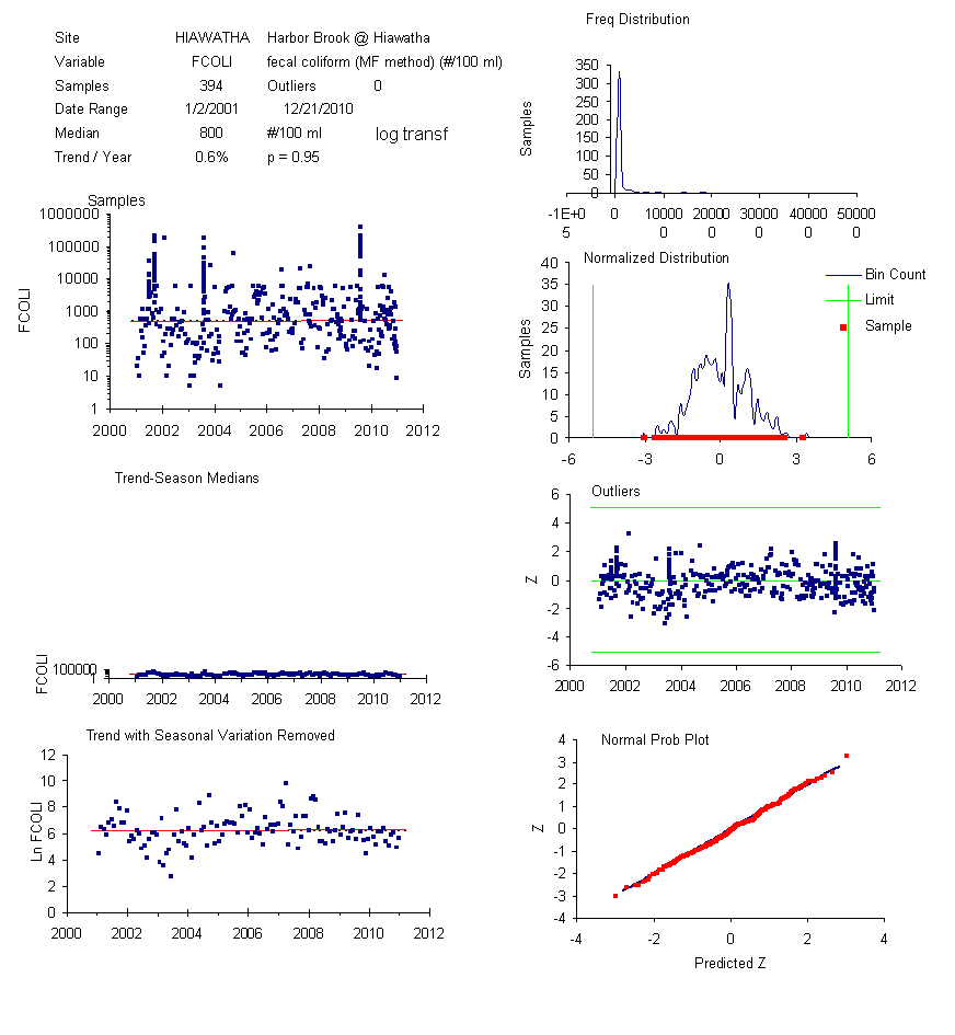
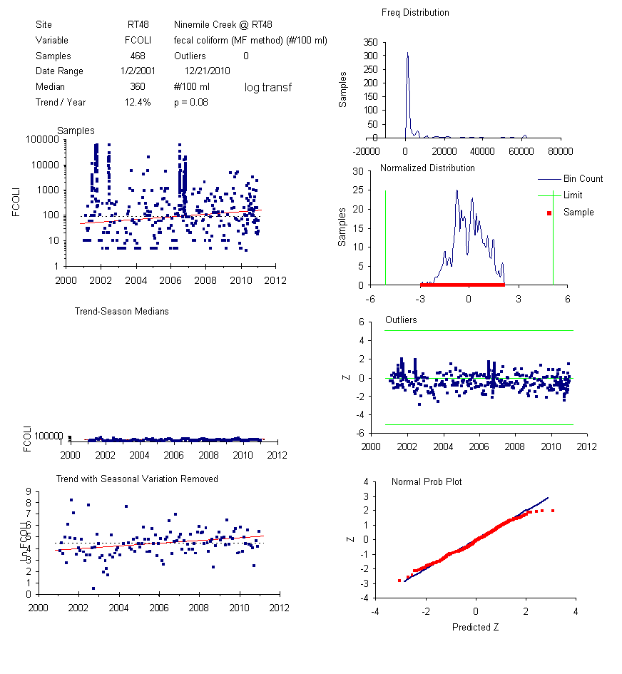
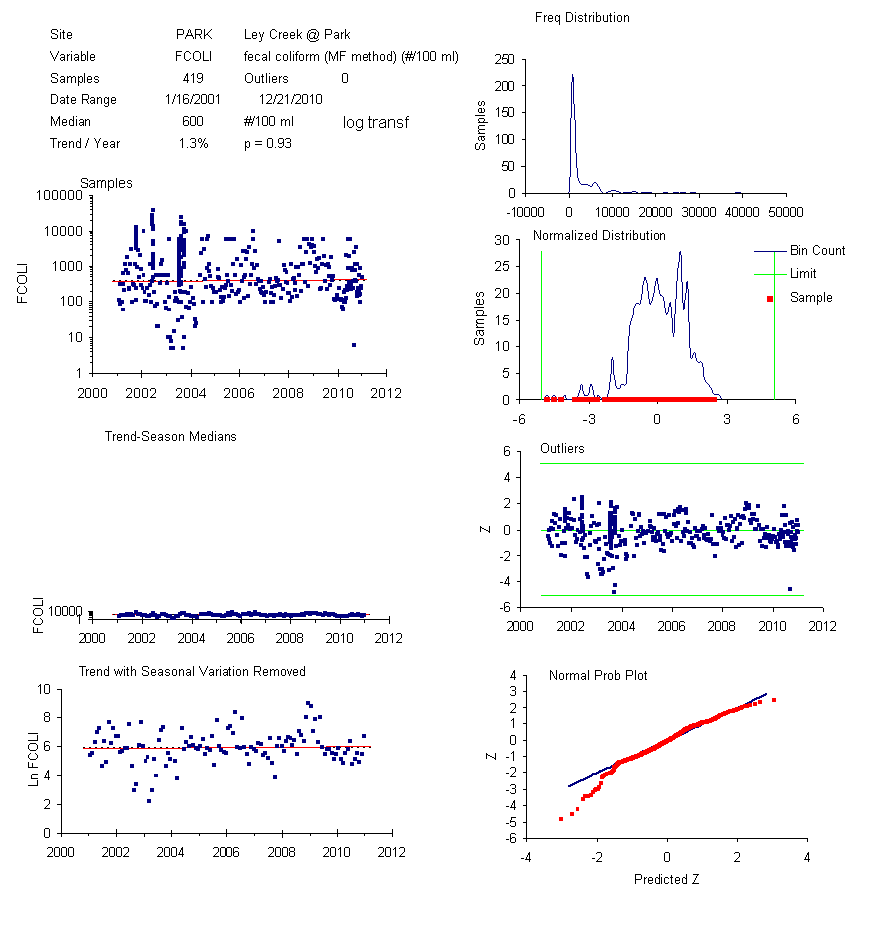
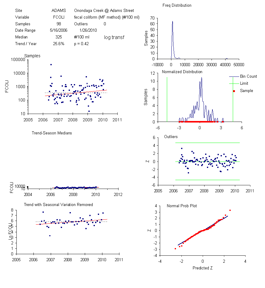
Fecal Coliform Trends at Lake & Tributary Sites (2001-2010) |
|
|
|
|
|
|
|
|
|
| All
Sites - Samples |
All
Sites - Monthly |
|
|
|
|
|
|
|
|
|
|
|
|
|
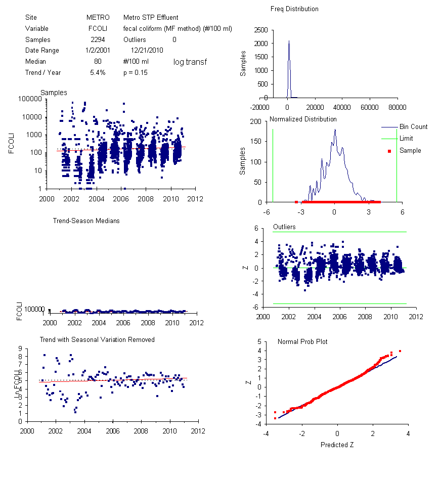
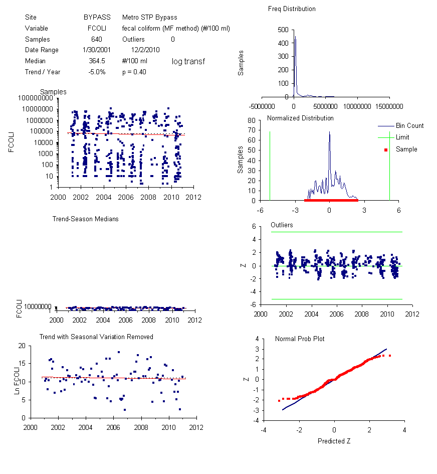
| Metro
Discharge |
Metro
Bypass |
|
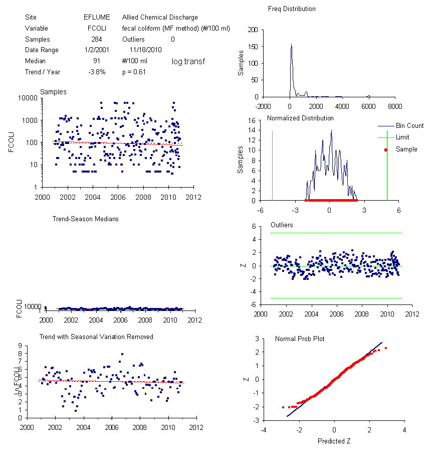
East
Flume |
|
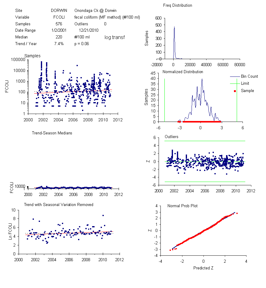
Onondaga
- Dorwin |
Onondaga
- Kirkp |
Trib
5A |
|
Lake
South |
| Harbor
- Velasko |
Harbor
- Hiawatha |
Ninemile
Creek |
|
Ley
Creek |
|
Adams |
|
|
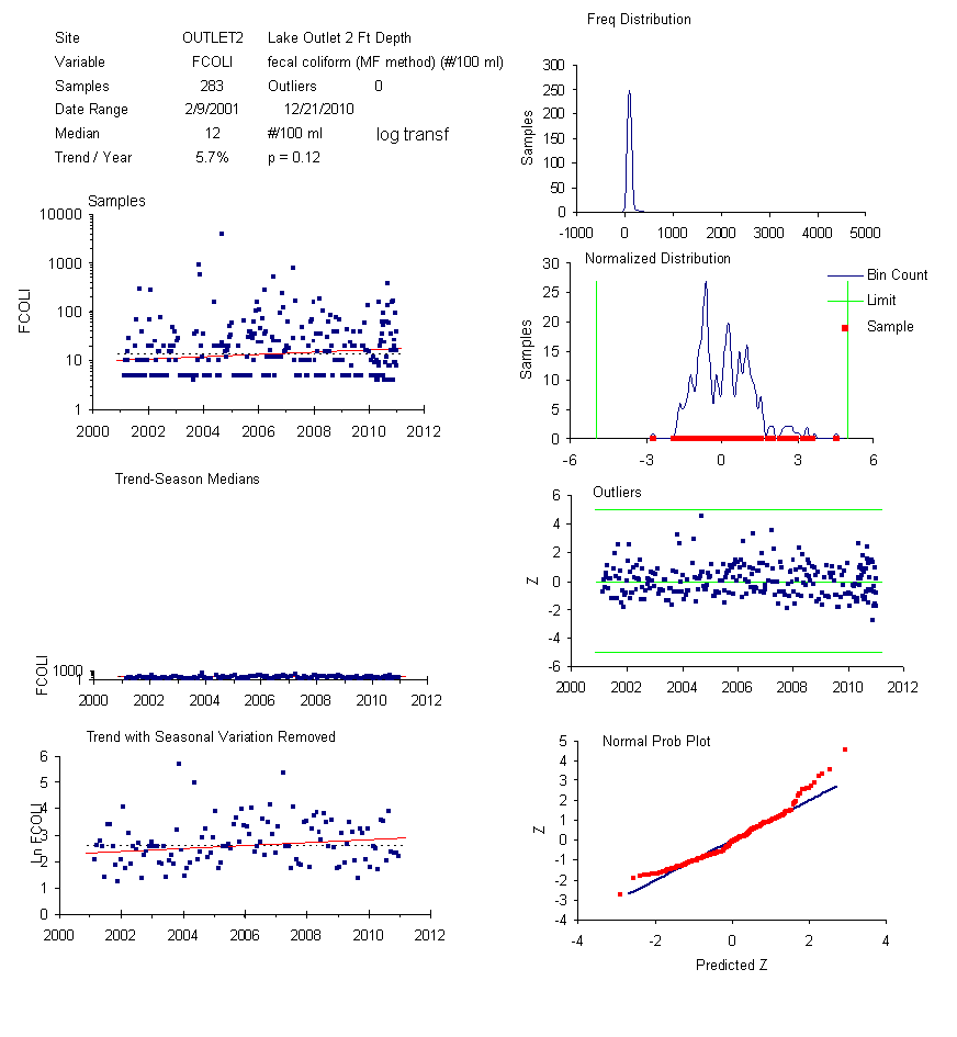
Outlet
2 ft |
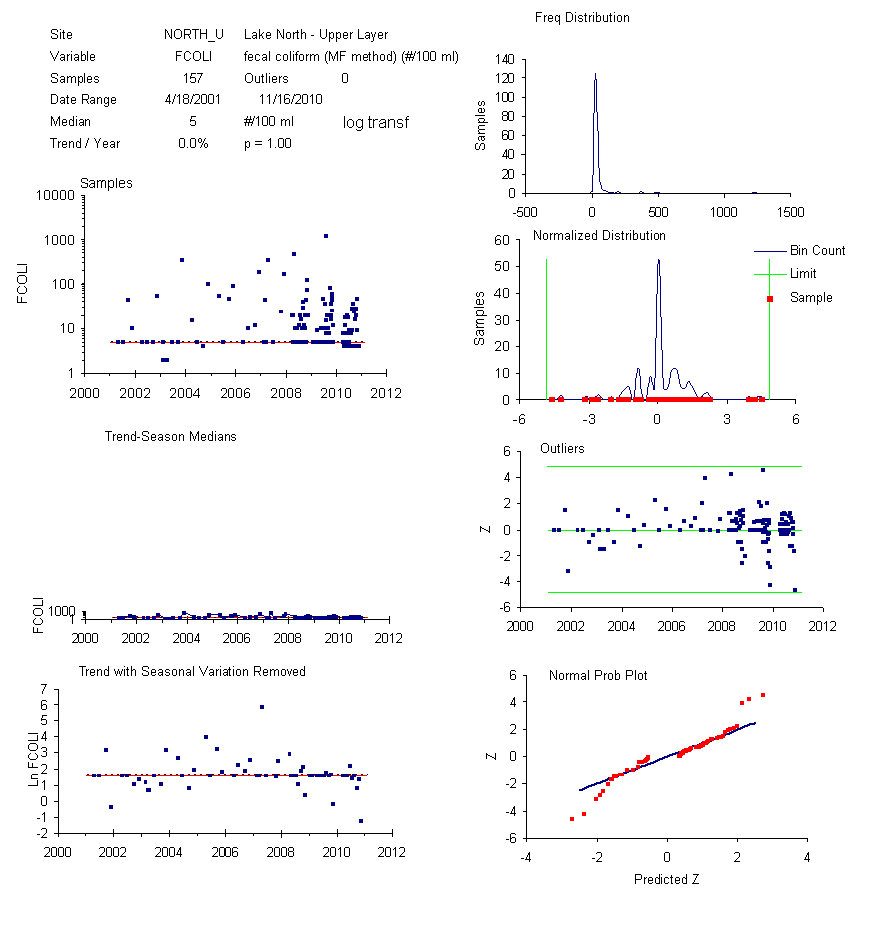
Lake
North |
|
|
|
|
|
|
|
|
|
|
|
|
|
|
|
|
|
|
|
| Software Packages
Used in This Analysis |
|
|
|
|
|
|
|
|
|
|
|
|
|
|
| R Project Software |
R General
Library |
R Water Quality
Library |
|
GGPlot |
|
AMP
Water Quality Database |
|
|
|
|
|
|
|
|
|
|
|
|
|
|
|
|
|
|
|
|
|
|
| Reference Links |
|
|
|
|
|
|
|
|
|
|
|
|
|
|
|
|
| Onondaga County Dept of
Environmental Protection - Ambient Monitoring Program |
|
|
|
|
|
|
|
|
|
| Ecologic, LLC |
|
|
|
|
W.W. Walker |
|
|
|
Walker AMP Reports |
|
|
|
|
|
| AMP 2010 Report Index (Data thru
2009) |
|
AMP
2010 Report |
|
|
AMP
2010 Appendix Library |
|
|
|
|
| Summary
& Regulatory Requirements |
|
|
Lake
Status |
|
|
|
Recreational
Quality (Nearshore Data) |
|
|
|
| Metrics
(Performance Measures) |
|
|
Tributary
Bacteria Loads (Sec 05) |
Wet
Weather Sampling |
|
|
|
|
|
| Wet
& Dry Weather Sampling |
|
|
AMP 2011 Monitoring Design |
|
Statistical
Framework (2007) |
|
|
|
|
| Water
Quality Database |
|
|
|
Database
Output Viewer |
|
|
|
|
|
|
|
|
|
|
|
|
|
|
|
|
|
|
|
|
|
|
|
|
|
|
|
|
| Variable Index |
|
|
|
|
|
|
|
|
|
|
|
|
|
|
|
|
| Variable |
|
Description |
|
Units |
|
Transf |
Goals |
Notes |
|
|
|
|
|
|
|
|
| SECCHI |
|
|
Secchi Depth |
|
m |
|
- |
>1.2 m |
Guidance value (4 ft);.often constrained by lake
bottom |
|
|
| FREQ SECCHI <
1.2 m |
Percent of Values |
% |
|
- |
~0% |
% of Values Meeting NYSDEC Guidance Value (4 ft),
Class B Segments |
| TURB |
|
|
Turbidity |
|
NTU |
|
log10 |
|
Good Surrogate for Secchi Depth (5 NTU ~ 4 ft =
1.2 meters) |
|
| FCOLI |
|
|
Fecal Coliforms |
|
cfu/100 ml |
log10 |
< 200 |
Geometric Mean of At Least 5 Samples Per Month,
Class B Segments |
| FREQ_FCOLI >
100 |
Percent of Values |
% |
|
- |
|
Frequency of High Values (50% of Standard) |
|
|
|
| ECOLI |
|
|
E Coli |
|
|
cfu/100 ml |
log10 |
|
Constrained >= 5 to reflect changes in
detection limits |
|
|
|
|
|
|
|
|
|
|
|
|
|
|
|
|
|
|
|
|
|
| Long-Term
Monitoring Network for Onondaga Lake |
|
|
|
Established ~ 1968 : "before Earth Day &
Clean Water Act" |
|
|
|
|
|
|
|
|
|
|
|
|
|
|
|
|
|
|
|
|
|
|
|
|
|
|
|
|
|
|
|
|
|
|
|
|
|
|
|
|
|
|
|
|
|
|
|
|
|
|
|
|
|
|
|
|
|
|
|
|
|
|
|
|
|
|
|
|
|
|
|
|
|
|
|
|
|
|
|
|
|
|
|
|
|
|
|
|
|
|
|
|
|
|
|
|
|
|
|
|
|
|
|
|
|
|
|
|
|
|
|
|
|
|
|
|
|
|
|
|
|
|
|
|
|
|
|
|
|
|
|
|
|
|
|
|
|
|
|
|
|
|
|
|
|
|
|
|
|
|
|
|
|
|
|
|
|
|
|
|
|
|
|
|
|
|
|
|
|
|
|
|
|
|
|
|
|
|
|
|
|
|
|
|
|
|
|
|
|
|
|
|
|
|
|
|
|
|
|
|
|
|
|
|
|
|
|
|
|
|
|
|
|
|
|
|
|
|
|
|
|
|
|
|
|
|
|
|
|
|
|
|
|
|
|
|
|
|
|
|
|
|
|
|
|
|
|
|
|
|
|
|
|
|
|
|
|
|
|
|
|
|
|
|
|
|
|
|
|
|
|
|
|
|
|
|
|
|
|
|
|
|
|
|
|
|
|
|
|
|
|
|
|
|
|
|
|
|
|
|
|
|
|
|
|
|
|
|
|
|
|
|
|
|
|
|
|
|
|
|
|
|
|
|
|
|
|
|
|
|
|
|
|
|
|
|
|
|
|
|
|
|
|
|
|
|
|
|
|
|
|
|
|
|
|
|
|
|
|
|
|
|
|
|
|
|
|
|
|
|
|
|
|
|
|
|
|
|
|
|
|
|
|
|
|
|
|
|
|
|
|
|
|
|
|
|
|
|
|
|
|
|
|
|
|
|
|
|
|
|
|
|
|
|
|
|
|
|
|
|
|
|
|
|
|
|
|
|
|
|
|
|
|
|
|
|
|
|
|
| Map |
Label |
|
Description |
|
|
Class |
|
Start |
Region |
|
|
|
|
|
|
|
|
|
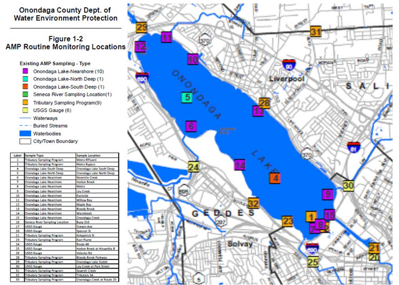
Lake Nearshore Sites (Sorted Clockwise) |
|
|
|
|
|
|
Pooled Nearshore Sites |
|
|
|
|
| 14 |
WBEDS |
Allied Waste Beds |
|
B |
|
2006 |
North |
|
LS_S |
|
Average of South Shore |
C |
|
| 6 |
9MILE |
|
Off NineMile Creek |
|
C |
|
1999 |
North |
|
LS_N |
|
Average of North Shore |
B |
|
| 12 |
MAPLE |
|
Maple Bay |
|
|
B |
|
1999 |
North |
|
LS_ALL |
|
All Nearshore Sites |
B/C |
|
| 11 |
WIL |
|
Willow Bay |
|
|
B |
|
1999 |
North |
|
|
|
|
|
|
|
|
| 10 |
LKPK |
|
Lake Park |
|
|
B |
|
1999 |
North |
|
|
|
|
|
|
|
|
| 13 |
BLBRK |
|
Bloody Brook |
|
|
B |
|
1999 |
North |
|
|
|
|
|
|
|
|
| 9 |
LEY |
|
Ley Creek |
|
|
C |
|
1999 |
South |
|
|
|
|
|
|
|
|
| 8 |
MID_S |
|
Mid South, Metro |
|
C |
|
1999 |
South |
|
|
|
|
|
|
|
|
| 14 |
HARB |
|
Harbor Brook |
|
|
C |
|
1999 |
South |
|
|
|
|
|
|
|
|
| 15 |
OC_OUT |
Mouth of Onondaga Creek |
C |
|
2008 |
|
|
|
|
|
|
|
|
|
|
|
|
|
|
|
|
|
|
|
|
|
|
|
|
|
|
|
|
|
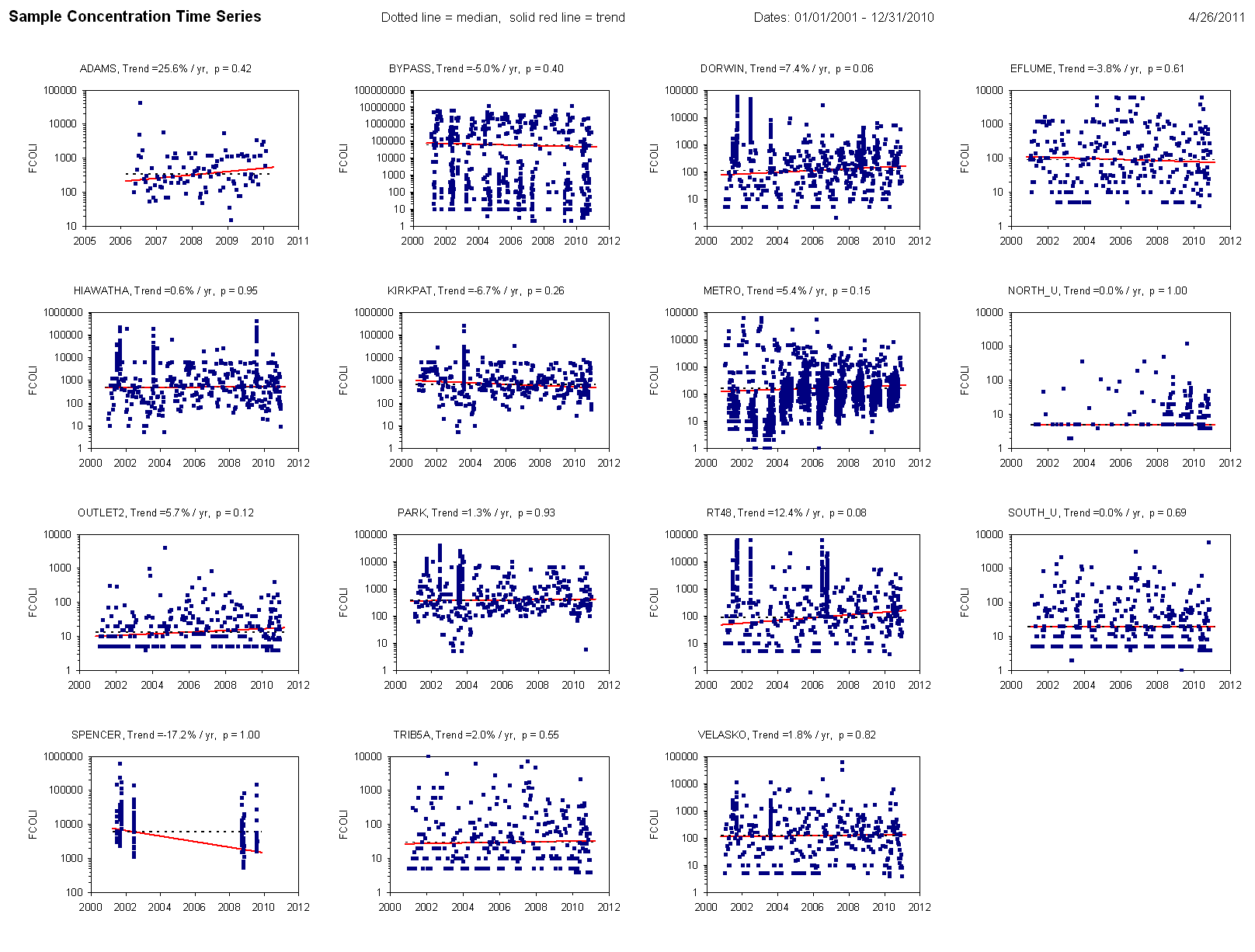
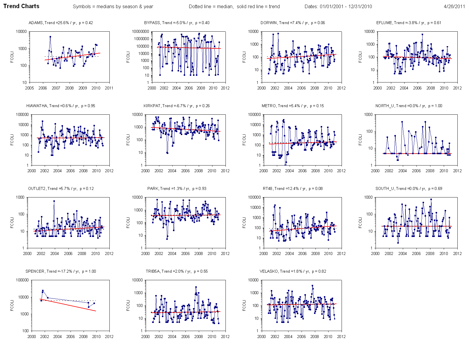
Lake & Tributary Sites |
|
|
|
|
|
|
|
|
|
|
|
|
|
|
|
| 4 |
SOUTH |
Lake Pelagic - South Deep |
|
|
<1990 |
|
|
| 5 |
NORTH |
Lake Pelagic - North Deep |
|
|
<1990 |
|
| 29 |
OUTLET12 |
Lake Outlet - 12 ft ~ Lake Net Discharge |
|
<1990 |
|
| 29 |
OUTLET2 |
Lake Outlet - 2 ft ~ Mixed with Seneca R. |
|
<1990 |
|
| 28 |
BLBRK |
|
Bloody Brook |
|
|
|
|
<1990 |
|
| 30 |
PARK |
|
Ley Creek at Park Street |
|
|
|
<1990 |
|
| 20 |
METRO |
Metro Discharge - Tertiary Tmt |
|
|
<1990 |
|
| 21 |
BYPASS |
Metro - Bypass - Primary Tmt) |
|
|
<1990 |
|
| 17 |
DORWIN |
Onondaga Creek - Dorwin Ave |
|
|
<1990 |
|
| 21 |
KIRKPAT |
Onondaga Creek - Kirkpatrick - Mouth |
|
<1990 |
|
| 26 |
VELASKO |
Harbor Brook - Velasko Road |
|
|
<1990 |
|
| 23 |
HIAWATHA |
Harbor Brook - Hiawatha Blvd |
|
|
<1990 |
|
| 24 |
RT48 |
|
Ninemile Creek |
|
|
|
|
<1990 |
|
|
|
|
|
|
|
|
|
|
|
|
|
|
|
|
|
|
|
|
|
|
|
|
|
|
|
|
| 07-07-2011 |
http://www.wwwalker.net/onondaga/report_2011/index.htm |
|
|
|
|
|
|
|
|
|
|
|
|
|
|
|
|
|
|
|
|
|
|
|
|
|
|
|
|